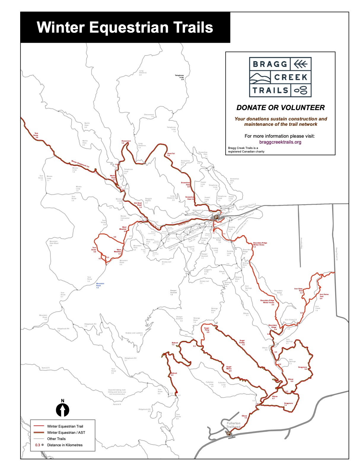
West Bragg offers ~50 km of winter equestrian trails which can be accessed from 3 different start points. There is something for every experience level.
Please follow all winter rules and ride only on designated winter equestrian trails until March 31.
Winter Equestrian Map
The Trails
Trail |
Distance |
Time Estimate** |
Elevation Gain |
Difficulty* |
|---|---|---|---|---|
NORTH & WEST (access – WBC) |
||||
| 1.8 km | 0:20 | 150 m | Intermediate | |
| Demitel | 1.6 km | 0:20 | 135 m | Intermediate |
| Reconnect | 1.6 km | 0:20 | 130 m | Intermediate |
| Moose (Singletrack) | 2.4 km | 0:25 | 170 m | Easy |
| Old Shell Road | 0.8 km | 0:10 | 40 m | Easy |
| Tom Snow (Moose Loop to north to Kestrel junction) | 5.0 km | 1:00 | 230 m | Easy |
| West Meadow/Tom Snow Loop | 3.0 km | 0:40 | 150 m | Easy |
| Snowy Owl (beside Mountain Road) | 2.0 km | 0:20 | 45 m | Easy |
CENTRAL (access – WBC, Range Road 54 or Hwy 66) |
||||
| Boundary Horse and Boundary Ridge (south of Iron Horse junction) | 4.5 km | 1:00 | 280 m | Intermediate |
| Iron Horse | 2.4 km | 0:30 | 185 m | Intermediate |
| Iron Vista | 1.3 km | 0:15 | 110 m | Intermediate |
SOUTH (access – Fullerton or Station Flats) |
||||
| Elbow (south) | 2.2 km | 0:50 | 105 m | Easy |
| Snagmore | 5.7 km | 1:10 | 360 m | Intermediate |
| Sugar Daddy | 3.6 km | 0:45 | 360 m | Intermediate |
| Sugar Mama | 3.4 km | 0:45 | 320 m | Intermediate |
| Sugar Pony | 0.9 km | 0:15 | 80 m | Intermediate |
| Tom Snow Station Flats to Bobcat | 2.4 km | 0:30 | 130 m | Intermediate |
| Bobcat | 3.6 km | 0:45 | 380 m | Difficult |
| Station Flats to Fullerton parking on side of hwy 66 | 1.4 km | 0:15 | 25 m | Easy |
| *Difficulty can vary due to snow and ice, and can change from day to day. Horseshoes with cleats are highly recommended due to ice and frozen ground.
** Time based on 5 km/hr travel speed |
||||
North and West (access – WBC):
Demitel – Reconnect (North Loop): This shared trail is being piloted for winter Equestrian Use during the 2020/2021 season. Its ongoing winter use will then be re evaluated. Note it sees considerable fat bike, snowshoe and foot traffic.
Start by crossing the road to the NE corner corner of the parking lot. Enter an equestrian access trail on the right to join Snowshoe Hare West. (Please do not use the shared ski/snowshoe/bike/walking trail). Continue up to DemiTel and follow that to Reconnect to descend and cross Telephone Loop ski trail. Follow a short shared section of Merlin View to descend to Old Shell Road trail, continue to Snowy Owl and return to the parking lot.
Moose Single track: Is accessed from Snowy Owl, which is shared with snowshoers, hikers and fatbikers. As the trail approaches the Texas gate on Mountain Road, cross the ski trail, and then cross Bragg Creek to the east side. Continue North on the reclaimed Old Shell Road to the intersection with Moose Loop and Telephone Loop ski trails, cross a short shared section west and up the hill onto the new Moose Loop All Season Trail. From here, you can ride to the end of this trail and back, or continue on to Tom Snow North.
Old Shell Road: Serves to connect Moose Single track with Snowy Owl.
Tom Snow/West Meadow: West Meadow trail continues from the western end of Snowy owl. Follow the blazes through the forest and when it breaks out into the Meadows, turn right or left to ride the loop with Tom Snow, which has lots of sun and great views. Return to the parking area via Snowy Owl.
Snowy Owl: Parallels Mountain Road through a beautiful meadow with stunning views to the west. It is shared with snowshoers, hikers and fatbikes. Short sections detour briefly onto Mountain Road to bypass beaver ponds and onto the ‘blue bridge’ to cross Bragg Creek.
CENTRAL (access – WBC, RRd 54 or Hwy 66):
Boundary Horse: This recently created out-and back trail can be accessed from the WBC parking lot. It begins ~ 50 meters south of the south PRA bridge where it veers left initially through dense forest followed by varying terrain opening out onto incredible views. To return to parking, trace your route back.
Iron Horse/Iron Vista: Is accessed from Range Road 54. Iron Horse parallels the Iron Creek Ski Trail and accesses both Boundary Horse and Snagmore. Iron Vista branches off of Iron Horse and provides a loop that has great views and a bit of climbing. Please note, there is no trailhead parking on RR 54.
SOUTH (access – Fullerton/Stn Flats):
Elbow(south): Leaves from the Fullerton trail head and is the access trail for all south trails.
Snagmore: Is accessed From Fullerton trailhead via South Elbow and has views of the Elbow River and up higher of the entire area. It connects to the south end of Boundary Horse, which also connects to Iron Horse, but for a shorter loop a new Snagmore-Elbow Link trail connects to Elbow Trail and back to parking.
Sugar Daddy/Sugar Mama/Sugar Pony: These are advanced trails created for biking/walking/running. Winter equestrians may now use these challenging trails.
Bobcat: Is rated as difficult due to its steepness and the presence of multiple switchbacks. Advanced riders are rewarded with stunning views to the west. Access is off Sugar Mama via Fullerton Trail Head


